
Methods
For more information, please contact mara@mrcirl.org
Overall Health Assessment
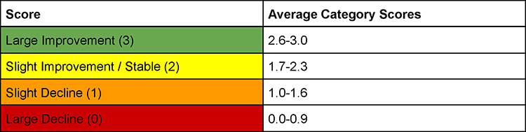
The general health assessment of the Indian River Lagoon basins was determined by averaging the scores of three different categories: harmful algal blooms, water quality, and seagrass coverage. Sediment health and wastewater spills are shown as point data and not included in the overall grade due to the variable nature of the data. Data points are from August 1, 2025 – August 1, 2026. The following values were used to categorize the general assessment scores.
See our data sheets.
Sediment Health Assessment
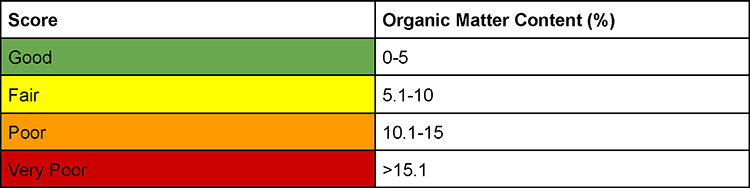
The sediment health assessment of the Indian River Lagoon basins was determined using data obtained from Marine Resources Council field work, Florida Institute of Technology, and Smithsonian Fort Pierce Marine Station. Watershed Information Network (WIN) showed no results for sediment health from August 1, 2025–August 1, 2026. Instead, data was shared by labs who study sediment around the lagoon. Still, sediment data is few and far between. It was decided to show data from the past several years (2023–2026) as points instead of a general basin score due to the lack of comprehensive data from throughout the lagoon for this year’s date range. Organic matter content (%) was chosen as the indicator of sediment quality as it is directly related to benthic community composition. An organic matter content greater than 5% is considered unhealthy. The following values were used to categorize the point scores.
Acknowledgements
Thank you to Florida Institute of Technology and Smithsonian Fort Pierce Marine Station for sharing their data.
Wastewater Spill Assessment
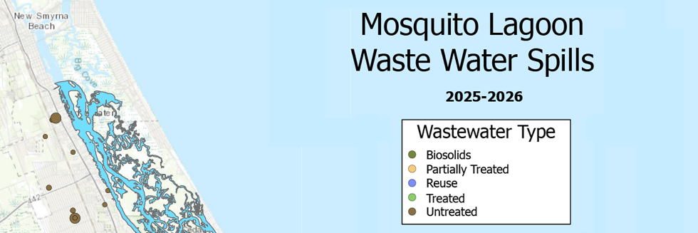
The wastewater spill assessment of the Indian River Lagoon basins was determined using data from the Florida Department of Environmental Protection. It was decided to show these data as points so that the size, composition, and quantity of spills could be visualized. This assessment was not chosen to be a basin score due to the variable nature of the data.
Acknowledgements
Thank you to the Florida Department of Environmental Protection for compiling and sharing the wastewater spill data for this project.
Harmful Algal Bloom Assessment
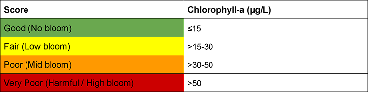
The harmful algal bloom (HAB) assessment of the Indian River Lagoon basins was determined using chlorophyll-a data from the Florida Department of Environmental Protection’s Watershed Information Network WAVES, South Florida Water Management District’s DBHYDRO, and St. Johns River Water Management District Environmental Data. Coordinate points for the blooms were unavailable, but it is important to note that even a small algal bloom can have long reaching effects, even if it does not reach harmful concentration levels. The following values from the Environmental Protection Agency for eutrophic estuaries were used to categorize the assessment scores.
Water Quality Assessment
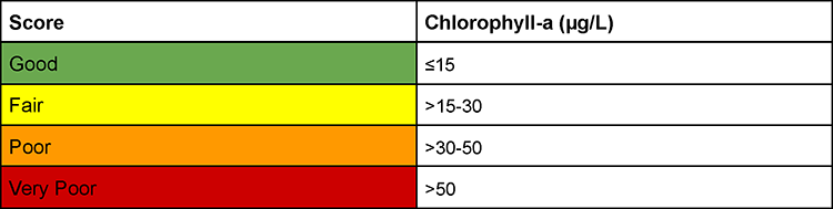
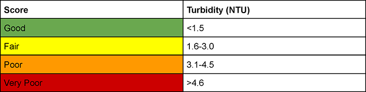
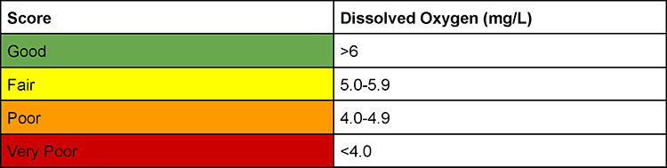
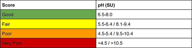
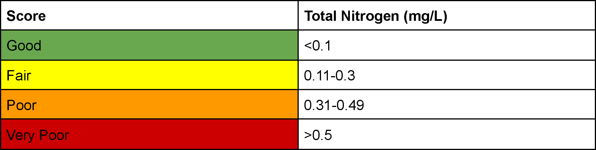
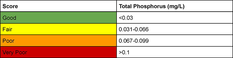
The water quality assessment of the Indian River Lagoon basins was determined using data from the Florida Department of Environmental Protection Watershed Information Network WAVES, South Florida Water Management District’s DBHYDRO, and St. Johns River Water Management District Environmental Data. Data was analyzed for dissolved oxygen (DO), turbidity, chlorophyll-a, pH, salinity, total nitrogen (TKN), and total phosphorus (TP-T). Median values were calculated to give each basin an individual score per subcategory. Finally, the subcategory grades were compiled and averaged to give the complete water quality assessment score. The following values were used to categorize the assessment scores. Breakdown of assessment score values was obtained from the Environmental Protection Agency.
Seagrass Coverage Assessment
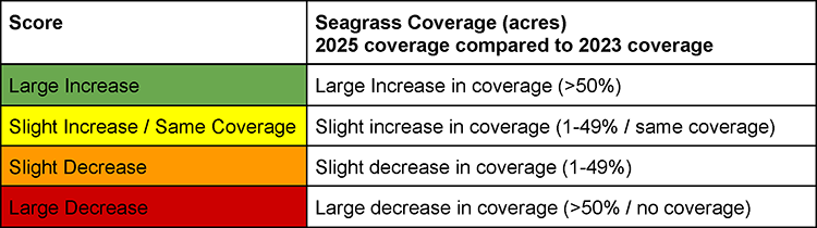
This year’s seagrass coverage assessment of the Indian River Lagoon basins was determined using mapping coverage data from St. Johns River Water Management District. Data is collected and analyzed every two years, with the most recent data collection year in 2025. Seagrass coverage from 2023 was compared to coverage from 2025. MRC uses basin extents based on FDEP BMAPs to delineate the SJRWMD data. Thus, coverage values presented here do differ from SJRWMD, as they use sub-basins. See our basin boundary shape files here. The following values were used to categorize the assessment scores.
Acknowledgements
Thank you to St. Johns River Water Management District (especially Lorae Simpson and Lauren Hall) for providing the seagrass mapping data.
Salinity
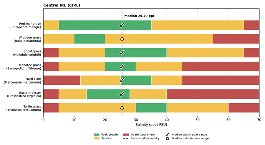
At the recommendation of experts in the field, salinity data were included in this year’s Report. Salinity data was sourced from the Florida Department of Environmental Protection Watershed Information Network WAVES, South Florida Water Management District’s DBHYDRO, and St. Johns River Water Management District Environmental Data. However, salinity data are extremely variable across short times spans and distances. This makes it difficult to find meaningful trends. To gain context on salinity values, the peak growth thresholds of critical sessile organisms were compared to median basin salinity data. Organisms include: red mangroves, the eastern oyster, the hard clam, turtle grass, shoal grass, manatee grass, and widgeon grass. Salinity data are shown in a stacked chart for each basin.
Acknowledgements
Thank you to Holly Sweat, Lauren Hall, and Lorae Simpson for their input and advice on including salinity data.
From the Authors
All of the MRC Health Report data analysis is publicly available. This includes our ArcGIS project files as well as our boundary layer shape files. The goal of the MRC IRL Health Report is to be a living document that evolves with expert input and advances in science and data analysis. Past reports are also publicly available and are updated annually to reflect the current methods as well as the originally reported data.
Want to replicate the report? All WIN prompts and databases are noted above and in the publicly available files. Please contact the Marine Resources Council with any questions, concerns, or suggestions.
See our citations.
Your Financial Support Makes It Happen!
Donate to become an Annual Member Today!
Marine Resources Council (MRC) coordinates Lagoon-wide efforts to Save the Indian River Lagoon, but we need your support to succeed. It will take a community to save the Lagoon, working at all levels.
MRC is holding government workshops, coordinating diverse stakeholder groups, showcasing community leaders, and working with businesses and individuals to encourage actions that will help save the Indian River Lagoon.
This website is managed by the Marine Resources Council, a 501(c)(3) nonprofit organization that has been dedicated to protecting and restoring the Indian River Lagoon since 1983.
Marine Resources Council • 3275 Dixie Hwy NE, Palm Bay, FL 32905.
Community Workshops
Science
LagoonWatch
2025 Report
2024 Report
IRL Action Assemblies
Restoration
Mangrove Nursery
Education
Lagoon at Noon
Low Impact Development
2026 LID Conference
2025 LID Conference
2024 LID Conference
2023 LID Conference
2022 LID Conference
2021 LID Conference
Teacher Resources
Rain Barrels
Site development by Editype.